


ARAVIS AIGUILLE VERTE

nordan
User
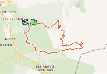

Length
10.1 km

Max alt
2317 m

Uphill gradient
895 m
Km-Effort
22 km

Min alt
1439 m

Downhill gradient
890 m
Boucle
Yes
Creation date :
2024-10-23 08:02:44.469
Updated on :
2024-10-23 13:21:13.078
3h38
Difficulty : Difficult

FREE GPS app for hiking
 SityTrail
IGN / Geographical institutes
SityTrail Plus
The world is yours!
About
Trail Walking of 10.1 km to be discovered at Auvergne-Rhône-Alpes, Upper Savoy, La Clusaz. This trail is proposed by nordan.
Positioning
Country:
France
Region :
Auvergne-Rhône-Alpes
Department/Province :
Upper Savoy
Municipality :
La Clusaz
Location:
Unknown
Start:(Dec)
Start:(UTM)
301479 ; 5085567 (32T) N.
Comments